EXISTING CONSTRAINTS
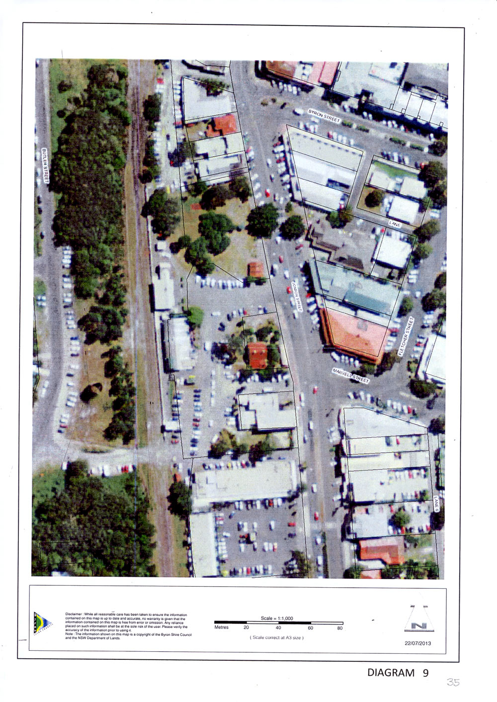
Railway Park is in the centre of the town and is the connecting focus of all other pathways which interconnect through this park. The area of the existing park and immediate surrounds is shown on photo diagram No 9. It is the place where people arrive and depart, come and go and gives the town that important sense of arrival. The park is opposite the central axis of the town Community Centre which gives this open area a civic focus and the ability to become a town square for important civil ceremonies. The existing area is not pleasant with an old public toilet having pride of place between a degraded car park area, the hotel as part of the station building and the abandoned railway line along the western boundary. The north section of the park has a significant tree and pleasant grassed areas but is difficult to maintain with the weekly night market during summer and other people intensive activities. The degraded car park and hotel service area extends to a laneway connecting Jonson Street to Butler Street across the railway line. This lane has a dilapidated house on one side and the ugly rear shop servicing area along the south side. A bus shelter on Jonson Street is in permanent use with many buses and tourist vehicles using this kerbside as the pick- up and set down area for the town. The tourist information centre is in an old historic weatherboard building surrounded by planting and trees.
POTENTIAL
Although this park is a disparate collection of degraded areas and unsympathetic buildings it has enormous potential to become:-
- a significant internal focus for all functions within the Town Centre
- a formal ceremonial space for civic functions
- a central point of arrival and departure for visitors
- a town square
- a place for small pop-up performances and buskers
- a place to sit, observe and relax with cafes and restaurants
- a transit centre for all visitors to pass through
- a centre for tourist information and directions
- a central pick-up and set down area for private cars and tourists
- a transition from regional to local transport modes
- an ideal location for a busy, operating railway station
- a tourist meeting and activity area
- a connection to Butler Street across the railway tracks
- a limited vehicle service connection to Butler Street
- a formal connection to the Community Centre
- a fully landscaped green park with co-ordinated landscaping to the town landscaped links.
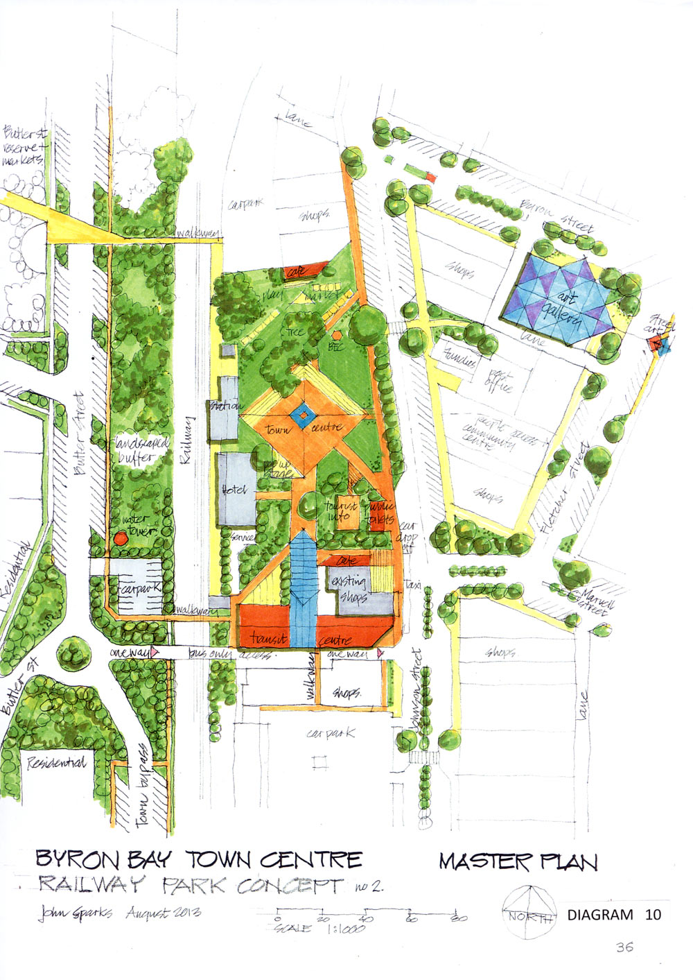
DESIGN CONCEPT
The design concept outlined on diagram No 10 shows how this central town area can realise its true significance and functions. The north part of the site retains the significant tree and grassed area for markets, buskers and small, more intimate gatherings. There is a suggestion for variation of the café boundary line to the northern adjoining property to open this corner to the street and provide a more pleasant outdoor area for both park and café.
Along the eastern side Jonson Street has been narrowed with removal of 5 car spaces and extension of the kerb line to give a significant landscape border to the park and improve the landscape. An open town square is located on the central axis from the Community Centre to the railway station building and this ceremonial space becomes the visual and people focus for the park. A popup stage allows small performances and the Byron Environment Centre Kiosk remains as an expression of the real Byron ethic. New public toilets are provided to replace the existing bus shelter and are set back into the landscaping to soften their impact and still provide a necessary amenity. The tourist information historic building remains with all its landscaping and a small café provides refreshment to passing tourists and travellers. A new transit centre is provided along the southern section of this park and extends through the old house site to Jonson Street. This allows a new upgraded transit facility building with kiosks for tour managers, directional information, public amenities, refreshment and waiting areas in a sustainable convenient all weather accessible environment.
This building connects travellers directly into the central town park instead of the existing unceremonious discharge onto the Jonson Street footpath. This transit centre is accessed by a one way bus and authorised vehicle only access from Butler Street, across the railway and through to Jonson Street where departing buses can travel north or south.
This not only keeps large tourist vehicles out of the narrow town streets with the congestion of small vehicles and people, but also provides a safe direct traffic flow based on convenient left-hand turns for arrival and departure. The transit centre can also become a meaningful showcase to give a good first impression for visitors after their weary journey. The thought of arriving in a beautiful natural park from a bus or train from distant regions is much more enjoyable and benefits the whole town with a happy tourist.
A vehicle service area is maintained for the hotel although this building would be more suited for a restaurant or art gallery as a focus for this community space. From the transit centre, walkways give a more direct pedestrian access to the adjoining shops, to Jonson Street and across the rail tracks to Butler Street. The car parking currently provided in the park area can be relocated in Butler Street where a small car park is shown near the water tower. A lot of additional parking can be accommodated within the Butler Street reservation by providing 45 degree angle parking along the full length of this section of road with the retention of the generous landscaped buffer zone between the street and railway reservation. These car parks are designed with groups of trees to break up the streetscape and reduce the impact of the cars. New walkways connect Butler Street directly with the central town area and Railway Park with new pedestrian rail crossings at convenient safe locations. This parking can also provide many extra spaces for market days as well as long term parking during the week for town access.
The connection between Railway Park and the library green space in Middleton Street is an important part of the town experience and a path through Fundies to the laneway to Fletcher Street and along Byron Street is seen as a significant experience along the walking journey through town. For this reason the site on the corner of Byron and Fletcher Streets is seen as a prominent site for an art gallery. This could be designed with a sacred geometry and sculptural theme on this three dimensional site. Geometric paving could extend across this intersection with the whole street area presenting a landscaped street art space as yet another experience to be enjoyed in this place called Byron. We certainly have the artistic talent and drive to produce this within our community and what a fitting statement this would be for the town.
ESSENTIAL COMPONENTS
To make this central town area a proper focus for the town with a civic square and the point of arrival for the continuous transits through our centre the essential components and principles are:-
- to increase the park area by moving the kerb line along the Jonson Street frontage
- to provide new toilet amenities with landscaping
- to retain the heritage tourist information centre building and landscaping
- to provide new cafes and meeting places
- to look at alternative uses for the station buildings
- to reactivate the railway line and station even for short journeys from the town periphery
- to relocate all car parking and extend the park green open space
- to provide additional parking along Butler Street with pedestrian walkways to the centre
- to provide a transit centre with full and efficient facilities
- to redirect bus and tourist vehicle arrivals through Butler Street and a new rail crossing.